Meadow Conditions on National Forest Grazing Allotments
Mountain meadows and riparian areas across the western United States constitute a unique and critical natural resource. On California's national forest lands, mountain meadows and their broader forested landscape provide a multitude of ecosystem services, including flood water attenuation, diverse and productive forage for cattle and wildlife, and outdoor recreation for over 26 million people. In response to concerns about grazing, meadow conditions, and threatened and endangered species, annual livestock use standards and guidelines for riparian areas were developed and incorporated into US Forest Service grazing allotment permits during the 1990s. There was, and remains, substantial debate over the adequacy and efficacy of these standards and guidelines to balance riparian conservation and livestock production goals.

 Trend in head of cattle on US Forest Service grazing allotments from 1980 through 2010 grazing. Reductions in number of head relative to 1980 numbers were 21, 38, and 49% in 1990, 2000, and 2010, respectively. The Region 5 long term meadow condition and trend monitoring program was initiated in 1998.
 Illustration of the design and example of the placement of permanent sample plots installed in meadows within USFS Region 5 grazing allotments.
In 1999, the US Forest Service Region 5 Range Program initiated a region-wide, long-term meadow condition and trend monitoring program to document baseline meadow conditions as these new riparian standards and guidelines were coming into use; and examine long-term trends in meadow condition following implementation of these riparian standards and guidelines. In 2012, a partnership was established between the US Forest Service Region 5 and the UC Rangelands to conduct the first comprehensive analysis of this unique dataset. We are examining:
-
- meadow conditions and trends; and
- relationships between meadow conditions and trends, livestock management, weather and environmental drivers.
- Relative Frequency Data
- Ratliff Vegetation Score and Condition Classification
- Species Richness and Diversity
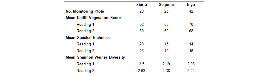
Comparison of meadow vegetation condition metrics for long-term monitoring plots located across the Sierra, Sequoia, and Inyo National Forests

US Forest Service Region 5 Range Program long-term meadow condition and trend monitoring sites and allotments.
Related publication: Freitas, M., L.M. Roche*, D.W. Weixelman, K.W. Tate. 2014. Montane meadow plant community response to grazing. Environmental Management 54: 301-308. *Corresponding Author. Read more.
Restoration and Grazing Management on Mountain Meadows and Streams
Livestock grazing on stream associated mountain meadows in California can negatively impact riparian vegetation, stream stability, water quality, and wildlife habitat. However, we have observed degradation at some grazed meadows but not others. This reflects differences in grazing management and meadow/stream resiliency to grazing. We conducted a cross-sectional survey of grazed riparian areas to identify and promote sustainable riparian grazing management.

- Identify grazing management activities associated with healthy mountain meadow streams.
- Extend these recommendations to grazing managers, regulators, and policy makers.


